Alicia Wallace
Rossland News
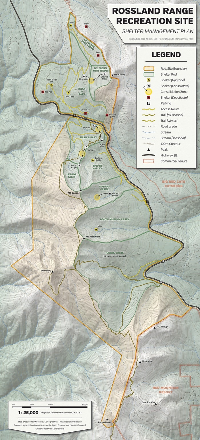
Friends of the Rossland Range Society (FORRS) held their annual general meeting (AGM) on Nov. 26 where they presented the approved Plan of Management (POM) for the Rossland Range Recreation Site. The site encompasses the mountainous area between Red Mountain Resort and the summit of Mt. Crowe. The terrain in the recreation site lends itself to numerous non-motorized uses in both summer and winter, comprising of alpine skiing, snowshoeing, and mountain biking amongst other activities.
Over time — 12 years in fact — it became obvious that the not-for-profit community group needed a POM. The recreation site boundary has been shrinking with crucial grizzly habitat on the decline and less space for the public to play.
“The boundary has been squeezed by a local cat operator and the community feels like the area is getting pinched. It is really important we don’t lose these places,” said Les Carter who is on the FORRS board of directors.
The provincial government — Recreation Sites and Trails Branch of the Ministry of Forests — to be exact, requires a POM to designate a recreation site. Now that the POM has been adopted, the community has a designated site for outdoor leisure pursuits.
“Over the years it became apparent that something more was needed in order to provide a secure future for public recreation in our hills… all in aid of gaining official status for our traditional playground,” the POM reads.
Those with experience in the Rossland Range estimate that recreational use of the area within the site has increased 10-fold over the past decade.
Carter expressed apprehension in regards to presenting the POM at the AGM. The community’s concern was that day use shelters would be torn down to make way for the new generation shelters. However Mr. Carter assured people that existing shelters would be “staying in place until the full transition.” The plan allows for nine, strategically placed, high quality day use shelters at the completion of the transition.
The strategy for placing new shelters comes from community consultation and taking into consideration a variety of factors including environmental impacts, access, proximity to the road, and a host of social considerations.
“Environmental impacts are a fundamental rule — locations were arbitrary in the first place. We will be asking people how would a hut feel here, where can people get firewood, can people pull a kid in on a sled,” Carter conveyed in regards to the strategy for shelter placement.
The plan aims to consolidate Surprise Hut and Eagle’s Nest Hut into a newly built shelter, located between the two existing huts. Carter explains that bureaucrats sometimes do not understand, and ask questions in regard to the need for either of these huts. Carter equates these huts to “a health care plan to motivate people to get out.” These are social huts that give people a positive destination, a place to socialize and give security to new users, older people and families. These shelters are key to bringing out large numbers of the public to exercise and experience the outdoors.
No deadlines have been earmarked as to when the end of transition will occur. It is now in the hands of the community to pick up the plan and run with it. With regard to funding, “private individuals have come forward, as have construction companies, offering to provide funds to the not-for-profit organization. Now that we have a POM we can act as the agent when applying for funding,” Carter said.
If you would like to get involved email FORRS at retrac01@telus.net or visit www.rosslandrange.org.