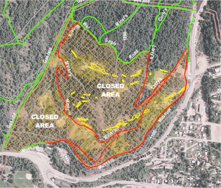
Teck presented plans to the public on Sunday, and council on Monday, to build roughly three kilometres of perimeter fencing around 100 acres of hazardous historic mining areas on the south side of Red Mountain, the same area that was "re-closed" in 2006.
The public meeting at the Prestige on Sunday was attended by about 15 people. "We got quite a bit of input, quite a bit of understanding of where we're going, appreciation of why, and suggestions we can take back to incorporate into our plans," said presenter Steve Hilts, the director of environmental risk assessment at Teck's Vancouver office.
The fence, to be completed in September, will run down the gas line north of the museum, along the high side of Museum Trail (the old rail grade from the museum to the junction of Hwy 3B and Kirkup,) then cut west, up through the woods to meet and follow the south side of War Eagle Road, allowing this trail to remain open.
The closed area contains a number of previously popular trails, notably Miner's, Larry's, and Museum trails, but Teck hopes they will be able to reopen Museum Trail in conjunction with the perimeter fence.
Teck has been a strong supporter of the Kootenay Columbia Trail Society (KCTS), accommodating many trails on Teck land, and funding the construction of two connector trails, Curly's and Moe's, to compensate for the sections of Larry's that were closed. Teck and KCTS have plans to build a third, low-angle, wide-track trail, but KCTS is currently pursuing higher priorities.
The fence itself will vary from 10-feet high (chain-link for eight feet and wire for two feet) in areas of heavy use near trails, to six-foot wood and wire fences in forested, low use areas.
This is not the first fence to surround the area. A barbed wire fence surrounded the old mines in the past, but since then has deteriorated to a few standing sections.
"Pretty much the whole area needs work," Hilts said, "When you go up there today and see rock and ground, it's a little deceptive."
Most of the mining was from 1890 to 1930. CMNS (then Cominco, and now Teck) began to take over the properties in 1906. In the depression of the 1930s, however, leases were granted to small operations whose documentation was incomplete, Hilts said. Consequently, "it's not fully mapped, even today."
Despite remediation efforts since the 1970s — "not all consistent with today's standards," Hilts cautioned — the area remains unsafe for public use.
In 2006, after a more thorough survey of the properties and the dangers posed, Teck closed the area with signs and barriers at the major entry points.
The area is covered with "unstable and unpredictable," features, Hilts said, "particularly the stopes, which drop almost vertically into the bedrock and were closed many years ago by just filling them with whatever was available."
Stopes are mined mineral veins that, on Red, range from one to several metres across. Other features include a limited number of large, room-size shafts that can be effectively capped, and many horizontal portals into adits that have been closed.
A map by Gilbert in the 1940s shows the mine features when they were still visible to the surface. Stoping was open at several places on trails and roads, and some stopes extend right underneath trails, "with maybe just a thin crown of rock left between the road and the void underneath."
Hilts showed a photograph of a mess of trashed vehicles and equipment extracted from one stope. With a lot more time and effort, Hilts said, better fill materials (such as waste rock) could have been found, but logs, timbers, railway ties, old equipment, and other wastes were used in addition to rock. Sometimes the fill merely "bridges" the top of a stope that can extend downwards for hundreds of feet.
"What you see on the surface doesn't look hazardous because you don't see these gaping openings," Hilts said, "but over time metal corrodes, wood rots, water flushes away the fines," and subsidence or collapse becomes a problem.
"This happens, every couple of years," he said, showing a picture of Le Roi Mine in cross section. With all the mines projected together, very little underground appears to remain.
Teck monitors the site every two weeks over prescribed routes for evidence of subsidence, and has been amassing geotechnical and environmental data in that time as well.
"This year we've got three new ones," he said, an older subsidence that dropped further, a subsidence "we've never seen before," and a third one near the highway where Teck had suspected there was a stope.
But people have frequently trespassed since 2006, Hilts said. "Despite information patrols [that] explain that the area is closed, and why, we still have people ignoring advice to steer clear."
Details of the fence have not been finalized. Discussion of its exact location continues — for example, Coun. Laurie Charlton pointed out some small parcels of city land that the fence would encompass, as drawn, a point Teck had not yet considered.
Some obstacles currently prevent Teck from reopening Museum Trail, namely the Centre Star stope that opened in 2005. Although it was capped, "a geotechnical engineer was not consulted when it was built," and it turns out the cap sits on a narrow ledge of potentially unstable rock. Hilts is "hopeful" about plans to add a second, free-standing cap to allow the trail to pass safely.
Furthermore, "we realize the fence is going to require monitoring and maintenance," Hilts said, in addition to their ongoing monitoring and mitigation work in the area itself.
Wildlife use of the 100 acres was not considered a significant issue. "There's not a lot of evidence of large animal use in there," Hilts said, based on a biologist's report. Although some bears and deer use the area, much of it is degraded habitat. The major inhabitants appear to be squirrels.
Esthetics are also under consideration to mitigate the visual impact of a tall fence beside public trail. The use of coloured enamel coatings on the chain-link is being considered, for example, or historical and educational banners and signs.
Coun. Kathy Moore commented afterward that people recognize Teck's genuine liability concerns. "I think the community should be very grateful that Teck is willing to consider the needs of the community as well as offering to build the trails, and trying to get us back the Museum Trail, since it's such a critical link."